| Quick Facts: | Lake Erie |
|---|---|
| Countries: | USA & Canada |
| Group: | Great Lakes |
| Shore length: | 871 mi (1.402 km) |
| Surface elevation: | 577 ft (176 m) |
| Max. length: | 241 mi (388 km) |
| Max. width: | 57 mi (92 km) |
| Surface Area: | 9.910 sq mi (25.667 km2) |
| Average depth: | 62 ft (19 m) |
| Max. depth: | 210 ft (64 m) |
| Water volume: | 116 cu mi (480 km3) |
| Primary outflows: | Niagara River |
| Primary inflows: | Detroit River & Welland Canal |
Lake Erie is located in east central North America and it’s one of the five Great Lakes between Canada and the United States. It is the most southerly, the second smallest, and the shallowest of the Great Lakes. It is considerably reduced in size from its prehistoric predecessor, the glacial lake that formed here when the ice cap, spreading south, blocked the St. Lawrence River’s path to the sea.
Lake Erie borders four states of the United States—Michigan, Ohio, Pennsylvania, and New York—and the Province of Ontario in Canada. In the four states, some 11 million people live on land bordering the lake and, in Ontario, 1.5 million more. Major U.S. industrial cities along the lake shore are Toledo, Lorain, Cleveland, and Ashtabula in Ohio, Erie in Pennsylvania and Buffalo in New York. Detroit, in Michigan, is near the lake’s western end.
Economic Importance of Lake Erie
This concentration of industry on Lake Erie’s shores was a principal reason for its being known, in the late 1960s, as the most ecologically abused of all the Great Lakes.
At its west end, Lake Erie received the discharge of the Detroit River, which flows past several large industrial cities, including Detroit and Windsor, Ontario. This already polluted water was further contaminated by the cities along the lake. Some critics were calling Erie a “dead” lake, knowledgeable ecologists warning that it would soon become so if industry and citizens, including farmers, did not end pollution. Industrial discharges of tons and tons of chemicals, oils, and other substances; human wastes, untreated or insufficiently treated; overused phosphate cleaners; and runoffs of fertilizers and insecticides from tilled fields, all drain constantly into the waterway.
In the late 1960s a joint U.S.-Canadian commission stated, after six years of investigation, that necessary city and industrial waste-treatment facilities alone would cost—at 1968 prices—$1.3 billion on the U.S. side of Lake Erie and $211 million on the Canadian side. One of the first actions of the new U.S. Environmental Protection Agency was a demand in 1971 that Detroit and Cleveland stop their water pollution. In 1972 a U.S.-Canadian agreement banned the discharge of contaminants into the lake, and environmental damage subsequently abated.
Lake Erie, because of its shallowness, has been the graveyard of many ships, thousands of unwary boatmen, and even some experienced sailors. Violent squalls develop quickly, with merciless waves. The lake averages 58 feet (18 meters) in depth, its deepest point being 210 feet (64 meters), just southeast of Long Point, Ontario. Its greatest width is 57 miles (92 km), from Ashtabula to Port Talbot, Ontario. The lake’s water surface is 9,910 square miles (25,670 sq km), 4,980 square miles (12,900 sq km) of which is under U.S. jurisdiction.
Erie’s waters from March to December carry superfreighters loaded with iron ore, coal, limestone, grain, and other vital cargo. Numerous “salties” – deepwater craft – handle widely varied exports and imports via the St. Lawrence Seaway and the oceans.
Tourism and fishing
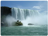
Despite the problems with ecology in Lake Erie, fine resort areas thrive at numerous points, particularly at Sandusky, Ohio, with its attractive islands and popular Cedar Point amusement park nearby; at Port Clinton, east of Toledo; at Erie; and, of course, at Niagara Falls, close to the lake’s eastern end.