| Quick Facts: | Lake Michigan |
|---|---|
| Countries: | USA |
| Group: | Great Lakes |
| Surface Area: | 22.300 sq mi (58.000 km2) |
| Max length: | 307 mi (494 km) |
| Max. width: | 118 mi (190 km) |
| Avg. Depth: | 279 ft (85 m) |
| Max depth: | 923 ft (281 m) |
| Water Volume: | 1.180 cu mi (4.900 km3) |
| Surface elevation: | 577 ft (176 m) |
Located in the north central United States, Lake Michigan is one of the five Great Lakes. It is the only one that lies entirely within the boundaries of the United States – the other four are partially within Canada – and it is by far the largest body of freshwater entirely within the United States. Lake Michigan is 307 miles (494 km) long and 118 miles (189 km) wide at its greatest width. It covers 22,400 square miles (58,000 sq km) and reaches a depth of 923 feet (281 meters). The lake, which is about 581 feet (177 meters) above sea level, empties into Lake Huron.
The southern two-thirds of the shoreline is regular, with no natural harbors. The northern portion is considerably indented, with many islands and good harbors. By far the greatest indentation is Green Bay, on the western side. Other major indentations are Grand Traverse and Little Traverse bays, to the east. The principal islands are the Beaver, Fox, and Manitou groups, and the islands extending across the entrance of Green Bay. In the mid-19th century, Beaver Island was the site of a Mormon colony and kingdom.
Lake Michigan’s drainage basin is but twice the area of the lake itself, and consequently no major rivers empty into the lake. Sand dunes border the lake for hundreds of miles, and two areas have been set aside as Indiana Dunes and Sleeping Bear Dunes national lakeshores. The extensive beaches make Lake Michigan a popular recreation area. The introduction of coho salmon and the restocking of lake trout attract fishers. Among the Great Lakes, Michigan is not as clean as Superior, but governmental jurisdictions have taken firmer stands against the dumping of industrial wastes into the lake.
Economic Importance of Lake Michigan
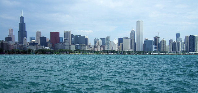
Economically, the Lake Michigan region received a boost in 1959, when the opening of the St. Lawrence Seaway provided access to world ports. However, most trade occurs with other Great Lakes ports. Relatively low-value, high-bulk commodities, such as grain and ores, are the principal items transported on the lake. Chicago, the nation’s third largest city, and the steel mills of Gary, Ind., dominate the southern end of the lake. Ice and bad weather interrupt navigation between December 15 and April 15.
Lake Michigan History
The first white to see Lake Michigan was Jean Nicolet of France. Other French explorers followed, including Father Jacques Marquette, who mapped the western shore, and the entire Great Lakes area was acquired by France. British rule supplanted the French in 1763, and American control of the area came in 1796, when Jay’s Treaty became effective. The construction of the Erie Canal and the opening of Lake Michigan to steamboats accelerated the settlement of the area in the second quarter of the 19th century.